


crayons: the Alberta Advantage
a new spine for Alberta

The Alberta Advantage is an idea in Albertan cultural lore that creates some nebulous and abstract “advantage“ to living in the province, whether that be for cost of living, the lack of rats, or the quality of hockey north of Red Deer (may Dustin Wolf not win the Calder this year).
The Alberta Advantage does not apply to passenger rail travel.
Intercity rail in Alberta has been in a steady decline over the last century, finally hitting a rock bottom it never escapes with the axing of the Super Continental CN transcontinental under Pierre Trudeau leaving only a singular rail line crossing the province horizontally from Wainwright, A.B., through Edmonton to Jasper, A.B. in operation today.
Rail between Calgary and Edmonton, the two main population centers in the province, has been under study for a long time now. Premier Danielle Smith’s UCP occasionally calls every few years for high speed rail and sinks a few tens of thousands of dollars into a study, but that’s usually where it’s killed or lost to time.
Here’s my take on Albertan rail. This is a smaller diagram than I usually do, which I credit to the fact I did this in about one afternoon and with minimal research. Thank you as always to OpenRailwayMap and Rail Guide for allowing me to be as lazy as possible when it comes to research.

Much of this is very unrealistic, I must admit — there’s no way a train to Saskatoon would take the curvier, slower Blackfoot Subdivision (via Lloydminster and Battleford) rather than the existing VIA Rail right of way on the Wainwright Sub. The only services drawn that I believe have even a slight chance of being completed are the low-speed line from Edmonton to Calgary, as well as maybe the line to Lethbridge. The rest of these are unrealistic at best, but that’s why crayons are great.
These routes also have nothing to do with historic CN, CP, or VIA routes. These are coming from scratch or existing routes.
what to look for
I designed this with a stronger adherence to grids in mind. Diagonal stations should be aligned, and the distance from station labels to station blobs should be entirely geometrically identical for the first time ever in SigPri history. I tried to avoid my usual habit of having geographically similar routes hold similar colors in the interest of accessibility, but that obviously didn’t go too well. I do believe the colors are distinct enough, and when used with the line bullets, should be more usable, but I could still see concern arising over the use of similar colors for colorblind accessibility.
what i liked

For Calgary and Edmonton, I put both their cities’ LRT systems beneath the intercity rail. Geometrically, this was more than a bit difficult to fit in. The Calgary LRT looks nothing like it does on this map, but I had to contort it to fit all the lines and have it still look vaguely like it should. I did also imagine a future connection from the CTrain Blue Line to Calgary Airport given the proximity of the two.

Bullets for each line are included at the line termini. You can see six different bullets for lines terminating in Calgary, and another five in Edmonton. These were quite easy to make, but surprisingly difficult to keep aligned with each other. The placement of the L line bullet in Calgary also means the high-speed line has to be shown at a slightly more awkward angle than its northern terminus in Edmonton, which I had imagined to be the ideal angle for both of them. Nevertheless, I am quite happy with how these turned out.
challenges faced

One particularly difficult aspect of this was fitting the entire damn line to Saskatoon in frame as well as the legend near it. I had considered three options for this: first, before doing the legend, the S line would come out horizontal east of Edmonton, then take a 90 degree turn between Battleford and Maidstone, which would give room for the legend on the right side of the map. This, however, created a massive void between the S line and the M line to Medicine Hat at the bottom that I was not keen on having; this version looked awful.
Second, I’d considered the bent version like this, but with it straightened out to a vertical line between Lloydminster and Maidstone, with the Saskatchewan stops appearing as vertical. This moved it far too close to the Medicine Hat branches, which would harm the usability and accessibility of the map.
Finally, I had devised the full bent version at the very start, but figured this would not be able to fit the whole key and legend in a vertical column on the right. I ended up solving this by moving the icon legend to the left of the line legend, as you can see in the full map at the very start of this article.
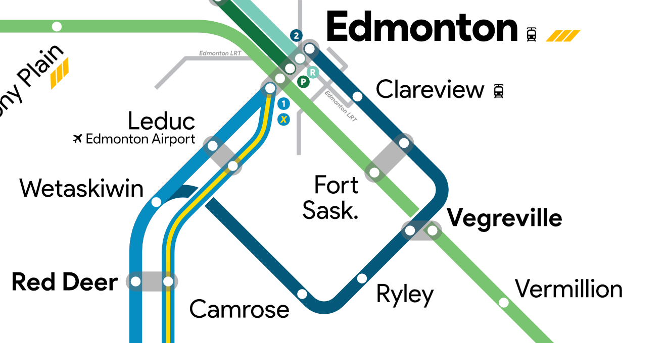
Serving Camrose, which is among one of the larger towns served on this crayon, was a unique cartographical challenge. I needed to figure out a way to both ensure I would still have space at my Calgary and Edmonton terminal blobs, while trying to indicate that this and the central-via-Leduc route were parallel for the vast majority of the route (which means less connector blobs would be needed). I ended up solving this by having a strange square shape curve off of the tracks around Wetaskiwin, where the track geographically does split, and to serve Camrose, Ryley, which is on the Wainwright sub that VIA serves (although it doesn’t stop in the town), Vegreville, which I turn into a relatively large interchange, Fort Saskatchewan, and Clareview, where the Edmonton LRT connects.
what to change
I think, for future reference, I could add provincial boundaries to the map with BC and SK stops marked beyond these boundaries. It would be a bit frustrating to both try to wrangle with a grid and relatively accurate provincial borders, but it would be a fun challenge in contortion.
On accessibility for vision impaired/colorblind folks: I’d come across a very interesting way to promote better accessibility in maps in a TransitMaps review from 2017. The designer of that map used different patterns to represent different lines, as well as some of the cleanest interchange blobs I have ever seen.
Alignment wise, I think a few stations here and there still seem a bit awkward. Nothing too major here.
you forgot to give rail to my GOAT fort mcmurray. fort mcmurray is the BEST albertan city they are the EPITOME of the alberta advantage and no line there is DISRESPECTFUL and a HEINOUS crime